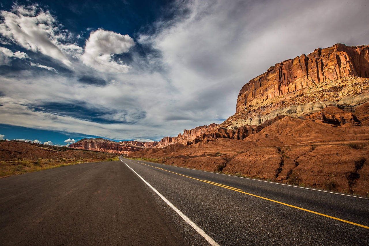
There’s a unique magic to it, isn’t there? The hum of the tires on asphalt. A perfect playlist flowing from the speakers.
The endless ribbon of road stretching toward the horizon. This is the great American road trip. It’s a feeling of freedom and discovery that you just can’t find anywhere else.
I’ve spent years chasing that horizon. I’ve explored winding mountain passes and sun-drenched coastlines. Now, I’m sharing my ultimate list. These are the absolute Best Road Trips in America.
We’ll journey from Appalachian peaks to Pacific cliffs. We will discover legendary routes and hidden gems. This guide has everything you need to plan your next adventure.
First, let’s get a bird’s-eye view of our journey.
Contents
- 1 14 Best Road Trips in America
- 2 East Coast Wonders & Appalachian Majesty
- 3 Heartland Routes & The Great River
- 4 Rocky Mountain Highs & Desert Landscapes
- 4.1 7. Going-to-the-Sun Road (Montana): Glacier’s Crown Jewel
- 4.2 8. Beartooth Highway (Montana & Wyoming): Top of the World
- 4.3 9. The Million Dollar Highway (Colorado): A Thrilling Mountain Drive
- 4.4 10. Scenic Byway 12 (Utah): A Journey Through Time
- 4.5 11. U.S. 50 (Nevada): The Loneliest Road in America
- 5 Pacific Dreams & Tropical Escapes
- 6 Your Next Great American Adventure!
14 Best Road Trips in America
| Scenic Highway | Location(s) | Distance | Best Season | Key Highlight |
| Blue Ridge Parkway | VA, NC | 469 miles | Fall | Appalachian Foliage |
| Kancamagus Highway | NH | 34.5 miles | Fall | Concentrated Autumn Beauty |
| Overseas Highway | FL | 113 miles | Spring | Driving Over a Turquoise Sea |
| Historic Route 66 | IL to CA | ~2,400 miles | Spring/Fall | Nostalgic Americana |
| Great River Road | MN to LA | ~3,000 miles | Varies | Following the Mighty Mississippi |
| Needles Highway | SD | 14 miles | Summer/Fall | Granite Spires & Narrow Tunnels |
| Going-to-the-Sun Road | MT | 50 miles | Summer | Alpine Majesty in Glacier NP |
| Beartooth Highway | MT, WY | 68 miles | Summer | Top-of-the-World Vistas |
| Million Dollar Highway | CO | 25 miles | Summer/Fall | Guardrail-Free Thrills |
| Scenic Byway 12 | UT | 124 miles | Spring/Fall | A Journey Through Geologic Time |
| U.S. 50, Nevada | NV | ~287 miles | Fall | Meditative Desert Solitude |
| Pacific Coast Highway | CA | ~600 miles | Spring/Fall | Iconic Coastal Cliffs |
| Columbia River Highway | OR | 75 miles | Spring | America’s First Scenic Roadway |
| Hana Highway | HI | 52 miles | Dry Season | A Tropical Rainforest Maze |
East Coast Wonders & Appalachian Majesty
Our journey begins in the East. Here, ancient mountains are draped in lush forests. History whispers from charming towns and pastoral landscapes.
These drives are about slowing down and soaking in the serene beauty of the American East.
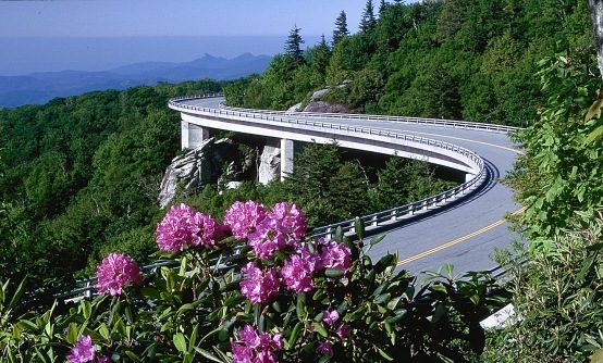
1. Blue Ridge Parkway (Virginia & North Carolina): America’s Favorite Drive
Nicknamed “America’s Favorite Drive,” the Parkway is a slow, peaceful journey through the Appalachian Highlands.
It was built during the Great Depression not just to connect two national parks, but to create an escape.
The road is intentionally non-commercial, designed to insulate you from the rush of the modern world. You’ll see stunning mountain views and deep valleys, all at a pace that lets you truly disconnect.
- Route Snapshot
-
- Route: Shenandoah National Park, VA, to Great Smoky Mountains National Park, NC.
- Distance: 469 miles.
- Best Season: Autumn. The world-class foliage is simply breathtaking.
- Drive Time: 3-5 days to truly savor it.
- Must-See Stops
-
- Linn Cove Viaduct (MP 304.4): This engineering marvel snakes around Grandfather Mountain. It was built from the top down to protect the delicate ecosystem below, a testament to the road’s thoughtful design.
- Craggy Gardens (MP 364.4): Famous for its stunning rhododendron blooms in early summer and incredible 360-degree views from the Craggy Pinnacle Trail.
- Waterrock Knob (MP 451.2): At over 6,000 feet, this spot offers some of the best sunrise and sunset views on the entire Parkway.
- Folk Art Center (MP 382): A wonderful cultural stop showcasing traditional and contemporary Appalachian crafts from the Southern Highland Craft Guild.
- Pro-Tips
-
- Check for Closures: Sections often close in winter due to ice and snow. Always check the National Park Service website before you go.
- No Gas on Parkway: There are no gas stations directly on the Parkway. Plan your fuel stops in adjacent towns.
- Embrace the Pace: The speed limit is a leisurely 45 mph for a reason. This drive is about the journey, not the destination.
Also See: These 12 Brilliant Apps Make Road Trips Easier, Safer, Cheaper and Way More Exciting
2. The Kancamagus Highway (New Hampshire): A Symphony of Fall Color
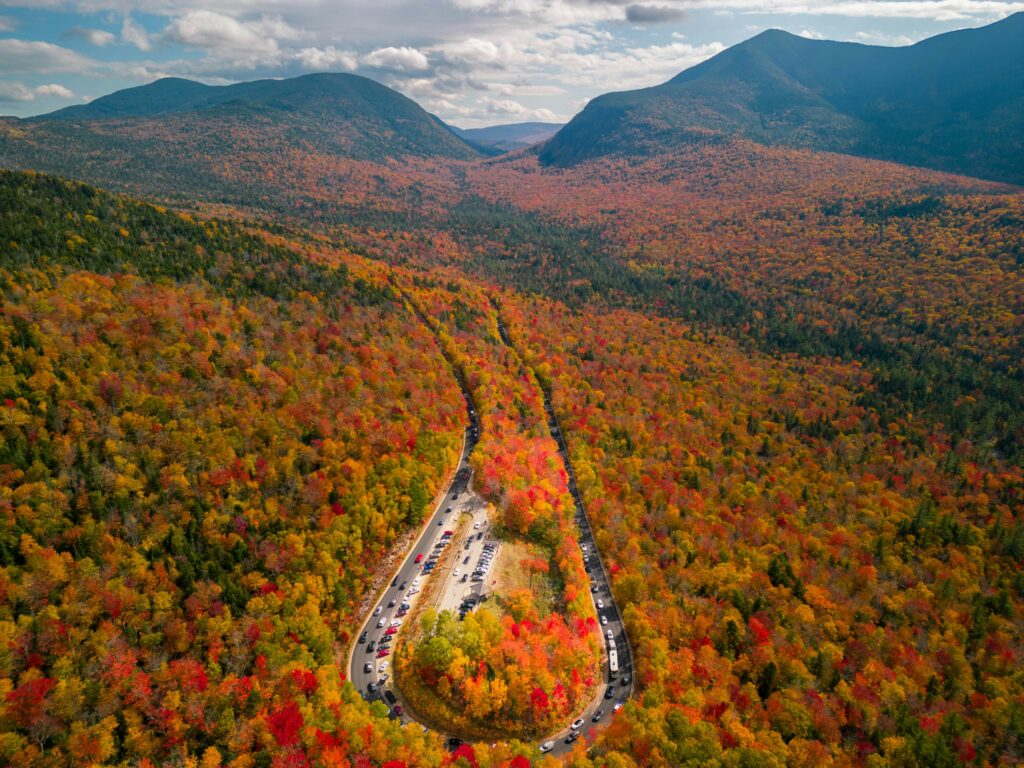
Locals call it “The Kanc”. This relatively short drive is a heavyweight champion of autumn beauty. It cuts through the heart of the White Mountain National Forest.
In fall, the mountainsides explode in a riot of red, orange, and gold. While epic cross-country routes are incredible, the Kancamagus proves that an unforgettable road trip can be packed into a single, perfect day.
It delivers world-class scenery in a concentrated, high-impact dose.
- Route Snapshot
-
- Route: Lincoln, NH, to Conway, NH, along NH Route 112.
- Distance: 34.5 miles.
- Best Season: Peak fall foliage, typically early to mid-October.
- Drive Time: A half-day to a full day with stops.
- Must-See Stops
-
- Sabbaday Falls: An easily accessible, multi-tiered waterfall just a short, pleasant walk from the highway parking area.
- Lower Falls: A popular spot where the Swift River cascades over broad granite rocks. It creates a natural water park perfect for a sunny afternoon.
- Hancock Overlook: Offers the iconic view of the hairpin turn. It’s a favorite for photographers capturing the sweep of the road and foliage.
- Sugar Hill Overlook: Provides a stunning, expansive vista of the Swift River Valley and layers of colorful mountains.
- Pro-Tips
-
- No Services: Like the Blue Ridge Parkway, there are no gas stations, restaurants, or hotels on the Kanc. Fill up your tank in Lincoln or Conway before you start.
- Go on a Weekday: The Kanc gets incredibly crowded on autumn weekends. A weekday trip is far more peaceful and enjoyable.
- Bear Notch Road: This seasonal road connects the Kanc to the town of Bartlett. It offers another scenic detour if it’s open.
3. The Overseas Highway (Florida): Island-Hopping to Paradise
Imagine driving on a ribbon of concrete suspended over a turquoise sea. That’s the Overseas Highway.
It leaps from island to island across 42 bridges, following the path of Henry Flagler’s ambitious “Over-Sea Railroad” from the early 1900s. The old, parallel bridges you’ll see are remnants of that history, a testament to the human will to connect these remote islands.
You’ll feel the tropical vibes with every mile marker you pass on this historic corridor.
- Route Snapshot
-
- Route: Key Largo (Mile Marker 107) to Key West (MM 0) on U.S. 1.
- Distance: 113 miles.
- Best Season: Late spring (March-May) for great weather and fewer crowds before the summer heat and hurricane season arrive.
- Drive Time: 3 hours without stops, but plan for at least a full day or a multi-day trip to truly experience the Keys.
- Must-See Stops
-
- Seven Mile Bridge (Marathon): The crown jewel of the highway. Driving over this 6.79-mile span feels like flying just above the water.
- Bahia Honda State Park (Big Pine Key): Home to one of the Keys’ most beautiful natural beaches, with views of the old Bahia Honda Bridge.
- John Pennekamp Coral Reef State Park (Key Largo): America’s first undersea park. It’s perfect for snorkeling or taking a glass-bottom boat tour.
- Key West: The end of the road! Explore Duval Street, visit Hemingway’s home, and enjoy the nightly sunset celebration at Mallory Square.
- Pro-Tips
-
- Take Your Time: The motto of the Keys is “slow down.” A hurried approach misses the point entirely. Savor each island’s unique character.
- Eat Key Lime Pie: It’s a local delicacy and a must-try. I recommend the towering meringue at Blue Heaven or the classic slice at Kermit’s Key West Key Lime Shoppe.
- Watch for Key Deer: In the Big Pine Key area, these miniature deer are a protected species. Drive carefully and admire them from a distance.
Also Read: California, the King of Road Trips: 11 Scenic Drives You Must Take Once in Your Life
Heartland Routes & The Great River
Now we head to the heart of the country. These roads tell the story of America’s growth, ambition, and soul.
From the nostalgic Mother Road to the river that defines the nation, these drives are about connecting with the American spirit.
4. Historic Route 66 (Illinois to California): The Mother Road
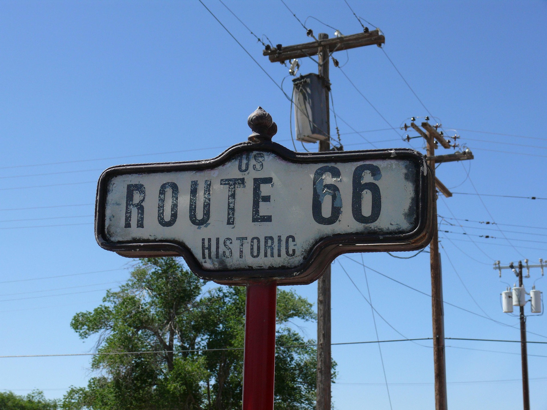
It’s the road trip of all road trips. Route 66 is a journey into the heart of American nostalgia.
Since it was officially decommissioned in 1985, the “Mother Road” no longer exists as a continuous highway.
This means your journey is an act of discovery, piecing together the path through a living museum of Americana.
You’ll find quirky roadside stops, neon-lit motels, and classic diners that feel frozen in time. This trip is all about the journey.
- Route Snapshot
-
- Route: Chicago, IL, to Santa Monica, CA.
- Distance: Approximately 2,400 miles.
- Best Season: Late spring or early fall to avoid the extreme desert heat and potential winter closures in the Midwest.
- Drive Time: At least two weeks are needed to do it justice; three is even better.
- Must-See Stops
-
- Cadillac Ranch (Amarillo, TX): Ten classic Cadillacs are buried nose-down in a dusty field. Bring a can of spray paint to leave your own mark on this ever-changing art installation.
- Wigwam Motel (Holbrook, AZ): Sleep in a concrete teepee at this iconic, beautifully restored motel. It’s a quintessential Route 66 experience.
- Blue Whale of Catoosa (Catoosa, OK): A classic, quirky roadside attraction built as an anniversary gift. It’s a perfect photo op and a symbol of roadside creativity.
- Santa Monica Pier (Santa Monica, CA): The official “End of the Trail” sign marks the finale of your epic journey. It’s a celebratory finish line on the Pacific Ocean.
- Pro-Tips
-
- Drive Westbound: If you can, drive from Chicago to LA. You’ll gain time as you cross time zones, giving you more precious daylight for exploring.
- Get Off the Interstate: The original Route 66 often runs parallel to modern interstates like I-40. Use a dedicated Route 66 guide or app to stay on the historic path.
- Talk to People: The soul of Route 66 lies in the stories of the people who live and work along it. Stop and chat with the owner of a restored gas station or a diner waitress.
Why Route 66 became America’s most famous road – Video Guide
5. The Great River Road (Minnesota to Louisiana): America’s Backbone
This isn’t one road but a collection of state and local roads that follow the mighty Mississippi River.
You’ll travel nearly 3,000 miles from a humble stream you can walk across to the vast delta at the Gulf of Mexico.
This drive mirrors the river itself, starting in the quiet Northwoods and ending in the vibrant culture of the South. You’ll witness a cross-section of America’s diverse identity.
- Route Snapshot
-
- Route: Lake Itasca, MN, to the Gulf of Mexico, LA.
- Distance: Approximately 3,000 miles.
- Best Season: Summer in the northern states; spring and fall in the southern states.
- Drive Time: 10 days to two weeks for the full length.
- Must-See Stops
-
- Lake Itasca State Park (MN): The official headwaters of the Mississippi River. You can literally walk across the stones where the mighty river begins.
- National Eagle Center (Wabasha, MN): Get up close with resident bald eagles and watch wild eagles soar over the river from their viewing platforms.
- Gateway Arch National Park (St. Louis, MO): A stunning monument to westward expansion on the banks of the river. Take the tram to the top for incredible views.
- New Orleans, LA: The grand finale. Experience the incredible music of the French Quarter, the delicious food, and the vibrant culture of the Crescent City.
- Pro-Tips
-
- Follow the Pilot’s Wheel: The route is marked by signs with a green pilot’s wheel logo. Keep an eye out for them to stay on track.
- Explore the River Towns: The real charm is in the small towns. Stop in places like Alma, WI, for its bluff-top views, or Hannibal, MO, Mark Twain’s boyhood home.
- Break It Up: Driving the entire 3,000 miles is a huge undertaking. Consider tackling one state or region at a time for a more manageable trip.
Read: 10 Once-in-a-Lifetime U.S. Road Trips Every Retiree Should Take Before It’s Too Late
6. Needles Highway (South Dakota): Through the Eye of the Needle
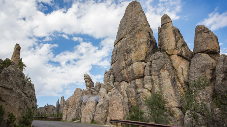
Prepare for a drive that feels like a magic trick. This 14-mile road in Custer State Park is an engineering marvel.
It was designed by a governor who marked the route on foot and horseback, intending for it to be an experience, not a commute.
Its tight turns, pigtail bridges, and narrow tunnels were built to force you to slow down and connect with the landscape.
You’ll squeeze through impossibly narrow rock tunnels and marvel at needle-like granite spires.
- Route Snapshot
-
- Route: A 14-mile stretch of SD-87 within Custer State Park.
- Distance: 14 miles.43
- Best Season: Late spring to early fall. The road closes after the first snow and doesn’t reopen until spring.
- Drive Time: About an hour, plus time for photos and short hikes.
- Must-See Stops
-
- Needle’s Eye Tunnel: The narrowest tunnel on the drive, measuring only 8 feet wide by 9 feet 9 inches high. It’s a true test for your vehicle and a thrilling moment.
- Cathedral Spires: Towering granite formations that pierce the sky. A short trail lets you get up close to these ancient, weathered giants.
- Sylvan Lake: A stunningly beautiful lake framed by massive granite boulders. It’s a perfect spot for a picnic, a hike, or just to soak in the scenery.
- Pro-Tips
-
- Know Your Vehicle’s Size: Large RVs and vehicles with trailers should avoid this road. The tunnels are extremely narrow, and there’s no room for error.
- Drive Slowly: Governor Peter Norbeck, who designed the road, said you should drive no more than 20 mph to do the scenery justice. He was right.
- Combine with Wildlife Loop: The Needles Highway is in Custer State Park, which also features the Wildlife Loop Road, famous for its massive bison herds.
Rocky Mountain Highs & Desert Landscapes
This is where the American landscape gets truly epic. We’re talking about drives that climb to dizzying elevations, cling to sheer cliffs, and cross vast, otherworldly deserts.
These roads are about drama, scale, and the raw, powerful beauty of the American West.
7. Going-to-the-Sun Road (Montana): Glacier’s Crown Jewel
This is one of the most spectacular drives on the planet. Carved into the mountains of Glacier National Park, it’s a 50-mile journey to the sky.
The road is an engineering marvel, but its existence is fragile. Each spring, crews battle snow drifts up to 80 feet high for ten weeks just to clear the path.
This short, precious window when the road is open makes the experience feel like a privilege.
You’ll see glaciers, cascading waterfalls, and abundant wildlife. It feels like driving through a masterpiece.
- Route Snapshot
-
- Route: Connects West Glacier to St. Mary in Glacier National Park.
- Distance: Approximately 50 miles.
- Best Season: Summer only. The road is typically only fully open from late June/early July to mid-October.
- Drive Time: At least 2-3 hours, but a full day is better to allow for stops and hikes.
- Must-See Stops
-
- Logan Pass: The highest point on the road at 6,646 feet. It’s a great place to spot mountain goats and hike the boardwalk to the stunning Hidden Lake Overlook.
- Wild Goose Island Overlook: The iconic, postcard-perfect view of St. Mary Lake, famously featured in the opening of The Shining.
- The Weeping Wall: A rock face where snowmelt cascades directly onto the road. You’ll get a free, refreshing car wash as you drive by.
- Big Bend: A wide, dramatic curve in the road with incredible panoramic views of the surrounding peaks. It’s a fantastic photo stop.
- Pro-Tips
-
- Reservations are Required: You need a timed-entry vehicle reservation to drive the road during peak season. Plan and book months in advance on Recreation.gov.
- Vehicle Size Restrictions: Vehicles over 21 feet long, 8 feet wide, or 10 feet tall are not permitted on the narrowest sections between Avalanche Creek and Rising Sun.
- Go Early or Late: To avoid the biggest crowds and find parking at Logan Pass, arrive before 7:30 AM or after 5 PM.
8. Beartooth Highway (Montana & Wyoming): Top of the World
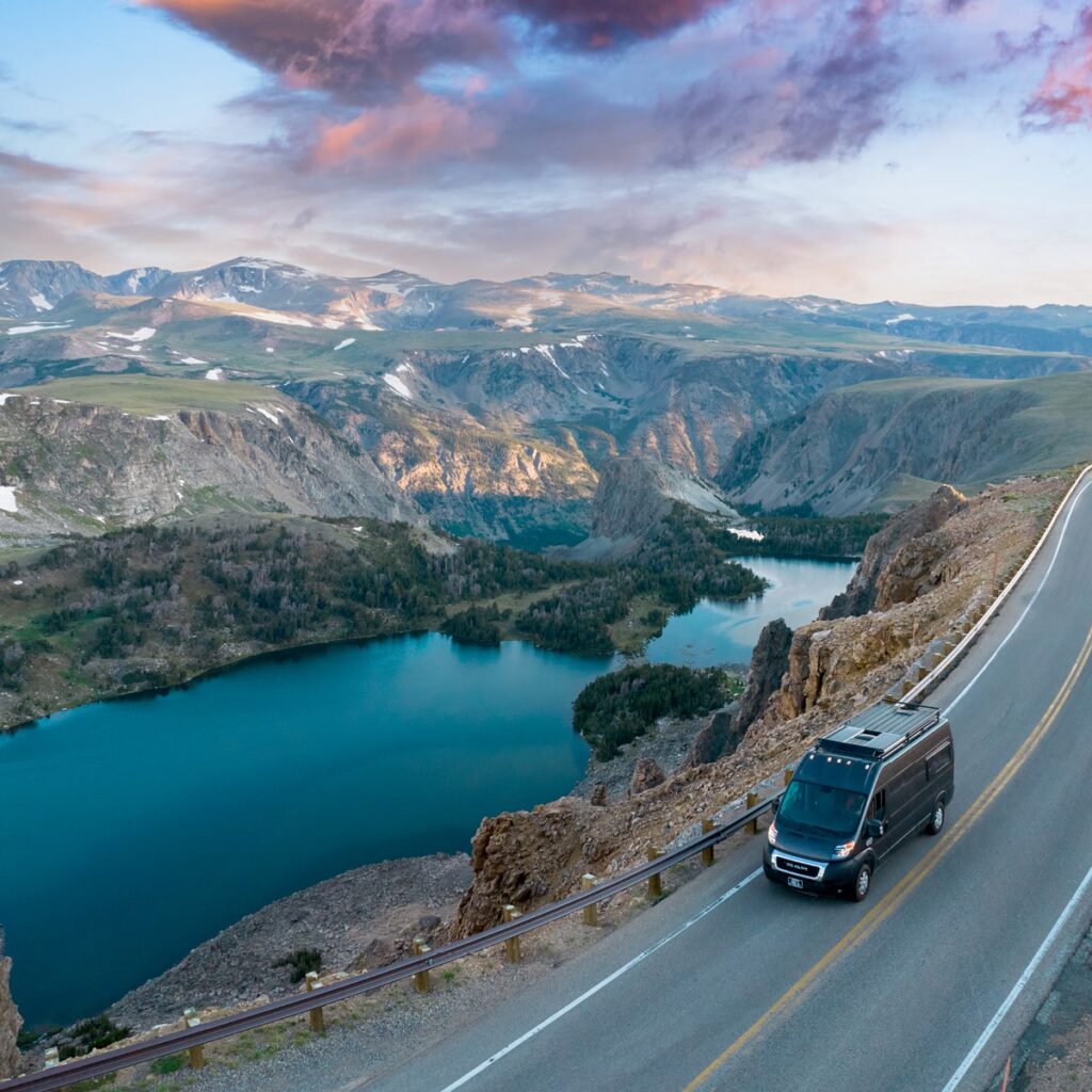
Famed CBS correspondent Charles Kuralt called it “the most beautiful drive in America”.
He wasn’t wrong. The Beartooth Highway is a breathtaking climb to nearly 11,000 feet, serving as a gateway to Yellowstone but existing as a destination in its own right.
It’s an immersive entry into the Absaroka-Beartooth Wilderness, one of the largest wilderness areas in the lower 48 states.
You’ll drive through alpine tundra and past glacial lakes. It truly feels like you’re on top of the world.
- Route Snapshot
-
- Route: Red Lodge, MT, to the Northeast Entrance of Yellowstone National Park via U.S. 212.
- Distance: 68 miles.
- Best Season: Summer only. It typically opens Memorial Day weekend and closes in mid-October, weather permitting.
- Drive Time: 2-3 hours, more with stops.
- Must-See Stops
-
- Beartooth Pass (10,947 ft): The summit. Stop to take in the 360-degree views of the Absaroka and Beartooth Mountains. The air is thin, and the views are endless.
- Rock Creek Vista: An observation point at 9,190 feet with stunning views of Rock Creek Canyon and the Hellroaring Plateau.
- Island Lake: One of many pristine alpine lakes dotting the high plateau. It’s a great spot for a picnic and a taste of the high-altitude serenity.
- Pro-Tips
-
- Check Road Status: The high elevation means weather can change rapidly. Snowstorms can cause temporary closures even in July, so always check the MDT 511 map.
- Watch for Wildlife: This area is home to grizzly bears, mountain goats, and moose. Be alert and keep a safe distance.
- No Services: There are no services between Red Lodge and Cooke City. Be prepared with a full tank of gas, water, and snacks.
Read: The 10 Most Scenic Fall Road Trips in the U.S for Unforgettable Autumn Views You Can’t Miss
9. The Million Dollar Highway (Colorado): A Thrilling Mountain Drive
Hold on to your steering wheel. This 25-mile stretch of U.S. 550 is famous for three things: steep cliffs, narrow lanes, and a distinct lack of guardrails.
The lack of barriers isn’t for thrill-seeking; it’s a practical measure to allow snowplows to push snow over the edge in winter.
But that practicality creates an unforgettable driving experience.
The thrill forces you to connect with the raw, untamed landscape. The views of the San Juan Mountains are, quite literally, worth a million bucks.
- Route Snapshot
-
- Route: U.S. 550 between Silverton and Ouray, CO.
- Distance: 25 miles.
- Best Season: Summer or early fall for the golden aspen trees. Winter travel can be extremely treacherous and is for experts only.
- Drive Time: About 45 minutes, but you’ll want to stop often.
- Must-See Stops
-
- Red Mountain Pass (11,075 ft): The summit offers incredible views of the iron-tinged mountains that give the pass its name.
- Ouray: Known as the “Switzerland of America,” this charming historic mining town is nestled in a stunning box canyon.
- Bear Creek Falls: A powerful waterfall that plunges 205 feet just below the highway. A viewing platform lets you appreciate its power.
- Pro-Tips
-
- Drive South to North: If you’re nervous about the sheer drop-offs, drive from Silverton to Ouray. You’ll be on the inside lane, against the mountain.
- Don’t Drive Distracted: This road demands your full attention. Let a passenger take the photos or pull over at designated turnouts.
- Check for Avalanches: The road crosses 70 named avalanche paths. It is frequently closed in winter for safety reasons.
10. Scenic Byway 12 (Utah): A Journey Through Time
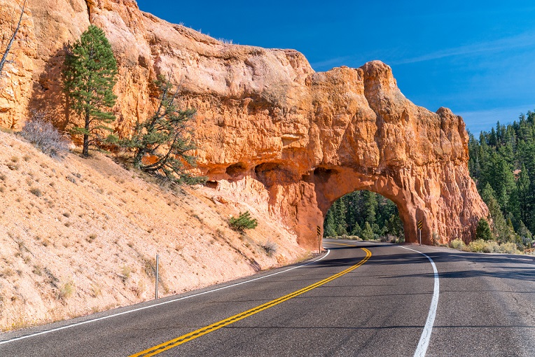
Scenic Byway 12 cuts through some of the most unique landscapes on Earth.
The drive is a narrative of our planet’s history. Each dramatic shift in scenery is a new chapter, from ancient seabeds to vast deserts and high alpine forests.
You’ll drive through red rock arches, over a razor-thin ridge, and into a completely different ecosystem. It’s like driving through another planet.
- Route Snapshot
-
- Route: Near Panguitch (U.S. 89) to near Torrey (SR 24).
- Distance: 124 miles.
- Best Season: Spring and fall for moderate temperatures and beautiful colors.
- Drive Time: 3 hours straight through, but plan for at least 1-2 days to explore properly.
- Must-See Stops
-
- The Hogback: A breathtaking section where the road runs along a narrow ridge with steep drop-offs on both sides. There are no guardrails here either, so focus!.
- Bryce Canyon National Park: A short detour takes you to the world’s largest collection of hoodoos—otherworldly red rock spires.
- Lower Calf Creek Falls: A 6-mile round-trip hike leads to a stunning 126-foot waterfall, a true oasis in the desert landscape.
- Grand Staircase-Escalante National Monument: Drive through vast, colorful layers of rock that represent millions of years of geologic history.
- Pro-Tips
-
- Fuel Up: Services are very sparse. Fill up your tank in Panguitch, Escalante, or Torrey.
- Check Conditions: The road is open year-round, but the high-elevation Boulder Mountain section can be icy and treacherous in winter.
- Don’t Rush The Hogback: This section demands focus. Pull over at the designated scenic spots to enjoy the incredible views safely.
11. U.S. 50 (Nevada): The Loneliest Road in America
In 1986, Life magazine called this the “Loneliest Road in America” and warned drivers to have “survival skills”.
Nevada cleverly embraced the title, turning a perceived negative into a celebrated attraction.
In a world of over-tourism, this drive offers something increasingly rare: true solitude.
This beautiful, meditative journey across Nevada’s Great Basin is just you, the open road, and the vast sky. It’s a road trip for the soul.
- Route Snapshot
-
- Route: The Nevada portion of U.S. 50, particularly from Baker to Dayton.
- Distance: Approximately 287 miles for the loneliest stretch.
- Best Season: Fall (September-October) for warm days and cool nights.
- Drive Time: 1-2 days to explore the towns and parks.
- Must-See Stops
-
- Great Basin National Park: Home to ancient bristlecone pines (some of the oldest living things on Earth) and some of the darkest night skies in the country.
- Eureka: A wonderfully preserved 19th-century mining town known as the “Friendliest Town on the Loneliest Road”.
- Spencer Hot Springs: Soak in natural hot springs under the wide-open desert sky. You might even hear the braying of wild burros.
- Hickison Petroglyph Recreation Area: A short, accessible trail leads to ancient rock art left by early inhabitants.
- Pro-Tips
-
-
- Get the Survival Guide: Pick up an official Highway 50 Survival Guide and get it stamped in five of the seven towns to receive a “survivor” certificate. It’s a fun challenge.
- Gas and Water: Services are very far apart. Never pass a gas station without filling up, and always carry extra water.
- Embrace the Loneliness: This trip is about solitude. Your phone won’t have service for long stretches, so download maps and music ahead of time and enjoy the peace.
-
Pacific Dreams & Tropical Escapes
Our final leg takes us to the edge of the continent and beyond.
These are drives defined by dramatic coastlines, where land meets the vast expanse of the Pacific Ocean, and where unique ecosystems create worlds unlike any other.
12. Pacific Coast Highway (California): The Ultimate Coastal Drive
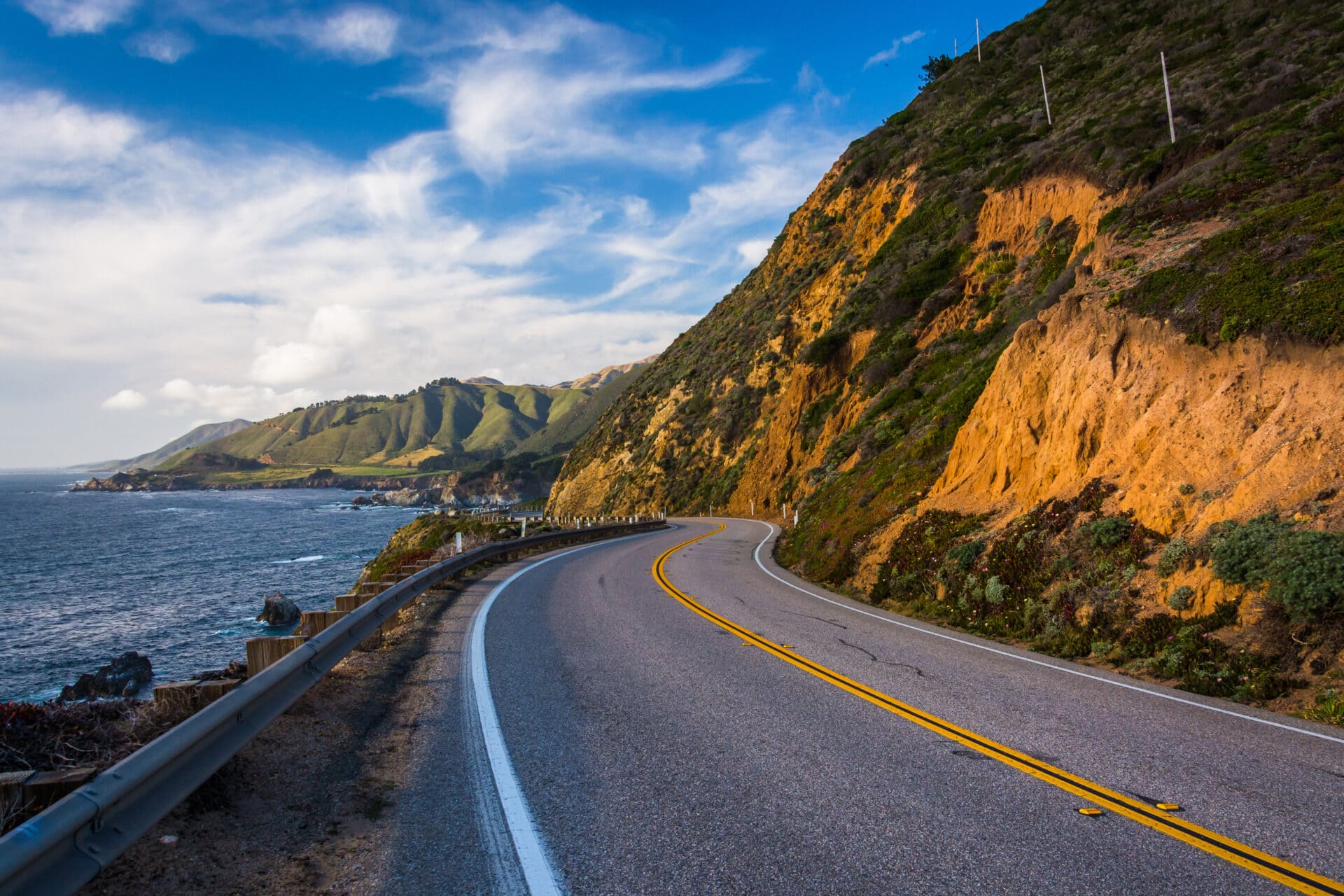
This is the drive dreams are made of. California’s Highway 1 is a legendary journey that clings to cliffs high above the crashing Pacific surf. But this is not a static, theme-park ride.
The PCH is in a constant battle with nature, and landslides can close sections for months.
This unpredictable character adds to the adventure. You’ll wind through redwood forests and charming beach towns on what is arguably one of the Best Road Trips in America.
- Route Snapshot
-
- Route: Officially 655 miles, but the classic, most scenic stretch is from San Francisco to Los Angeles/San Diego.
- Distance: Approximately 600 miles for the classic route.
- Best Season: Spring or Fall. Summer is beautiful but very crowded, and winter brings a high risk of landslides and road closures.
- Drive Time: 3-5 days minimum; a week allows for a much more relaxed pace.
- Must-See Stops
-
-
- Big Sur: The most dramatic and famous section. Don’t miss the iconic Bixby Bridge, McWay Falls cascading onto the beach, and Pfeiffer Beach with its unique purple sand.
- Monterey: Visit the world-class Monterey Bay Aquarium and grab a bread bowl of famous clam chowder on Fisherman’s Wharf. I love the chowder at Old Fisherman’s Grotto.
- Hearst Castle (San Simeon): The lavish and wildly eccentric estate built by newspaper magnate William Randolph Hearst. Book tours well in advance.
- Santa Barbara: A beautiful city with Spanish-style architecture, fantastic restaurants, and beautiful beaches. It’s the perfect place to relax for a day or two.
-
- Pro-Tips
-
- Drive North to South: This puts you on the ocean side of the road for the best, unobstructed views and makes it much easier to pull into the scenic turnouts.
- Check Caltrans: The Big Sur section is notoriously prone to landslides. Always check the Caltrans road status website before you go. Be prepared for detours.
- Book Lodging in Advance: Especially in Big Sur and other popular areas like Monterey and Santa Barbara, accommodations fill up months ahead of time.
Read: These 13 Stunning U.S. Beach Towns Prove the WEST Coast Really Is the BEST Coast!
13. Historic Columbia River Highway (Oregon): The King of Roads
Built over a century ago, this was America’s first planned scenic roadway. Known as the “King of Roads,” it’s a 75-mile masterpiece of engineering and natural beauty. Every curve and viewpoint was intentionally designed by engineers who modeled it after Europe’s great scenic roads, aiming to create a work of art.
You’ll drive past a staggering number of waterfalls, framed by handcrafted stone walls and graceful arches.
- Route Snapshot
-
- Route: Troutdale to The Dalles, OR (in sections).
- Distance: Approximately 75 miles.
- Best Season: Spring for the most powerful waterfalls and vibrant wildflowers.
- Drive Time: 3-5 hours, or a full day to include some hiking.
- Must-See Stops
-
- Multnomah Falls: The granddaddy of them all. A breathtaking 620-foot, two-tiered waterfall that is Oregon’s most visited natural site.
- Vista House at Crown Point: An elegant observatory perched 733 feet above the river. It offers one of the most famous and photographed views in the Pacific Northwest.
- “Waterfall Alley”: A short stretch of road that includes Latourell Falls, Bridal Veil Falls, and Horsetail Falls in quick succession. It’s an incredible concentration of beauty.
- Rowena Crest Viewpoint: Offers a dramatic, sweeping view of the gorge and the highway’s iconic horseshoe curve. A favorite spot for photographers.
- Pro-Tips
-
- Navigate the Sections: The historic highway is no longer continuous. You’ll need to use I-84 for a middle section. Follow the “Historic Highway” signs carefully.
- Hike and Bike: Parts of the old, abandoned road have been converted into the Historic Columbia River Highway State Trail, perfect for walking or cycling away from cars.
14. Hana Highway (Hawaii): The Road to Hana
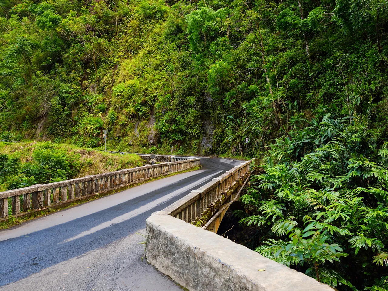
This is one of the most beautiful and challenging scenic highways in the world. The Road to Hana is a slow, winding journey through Maui’s lush rainforest.
You’ll navigate 620 curves and 59 one-lane bridges. Many people ask if the challenging drive is “worth it,” but that’s because they think Hana town is the destination.
It’s not. The road is the destination.
Every waterfall, hairpin turn, and jungle vista is the point of the trip. The reward is cascading waterfalls, black sand beaches, and a feeling of old Hawaii.
- Route Snapshot
-
- Route: Kahului to Hana on Maui’s Route 360.
- Distance: 52 miles from Kahului.
- Best Season: The dry season (April-October) is best, but be prepared for rain showers at any time of year.
- Drive Time: A full 10-12 hour day is required. This is not a drive to be rushed.
- Must-See Stops
-
- Wai’anapanapa State Park (Mile 32): Home to a stunning black sand beach, sea caves, and lava tubes. Advance reservations are now required to enter.
- Pipiwai Trail (Past Hana): Located in the Kipahulu District of Haleakalā National Park, this trail takes you through a dense, magical bamboo forest to the 400-foot Waimoku Falls.
- Twin Falls (Mile 2): One of the first and most accessible waterfall stops. A great place for a refreshing swim early in your journey.
- Roadside Banana Bread: It’s a cliché for a reason. Stop at a local stand like Aunty Sandy’s or the Halfway to Hana stand for some of the best warm banana bread you’ll ever taste.
- Pro-Tips
-
- Start Early: Leave your hotel before 7:30 AM to beat the traffic and have enough daylight for the whole journey.
- Let Locals Pass: You’ll see local residents who drive this road daily. Pull over at a safe spot and let them pass. It’s proper road etiquette and greatly appreciated.
- Pack Accordingly: Bring snacks, water, bug spray, and cash for the roadside stands. Cell service is non-existent for most of the drive, so download your maps and music beforehand.
Check: 13 American Towns So Beautiful They Won’t Stay Secret for Long (Visit Before They Go Viral)
Your Next Great American Adventure!
From the sun-soaked Florida Keys to the misty Oregon coast, these scenic highways offer more than just a route.
They offer a connection to the landscape, to history, and to the pure spirit of adventure. They are some of the Best Road Trips in America, each one a unique story waiting to be experienced.
The open road is calling. I’ve shared my favorite journeys.
Now it’s your turn to choose your path. So, pack your bags, fill up the tank, and go discover one of the Best Road Trips in America.