I love the open road.
In California, the scenery can flip from desert to redwoods in a single afternoon.
That sudden change is why I keep driving.
These 11 routes made me pull over, again and again — just to stare.
They’re views, short hikes, and perfect picnic spots rolled into one.
Drive carefully. Leave places better than you found them.
Ready to find your next unforgettable stop? Here we go.
Contents
Coastal Wonders: Where Land Meets Sea
The California coast is a place of dramatic cliffs and ancient forests. Crashing waves provide the perfect soundtrack for a drive.
This is why California’s one of the best states for road trips. You feel the power of the Pacific Ocean with every turn.
1. Pacific Coast Highway: The Ultimate Coastal Journey
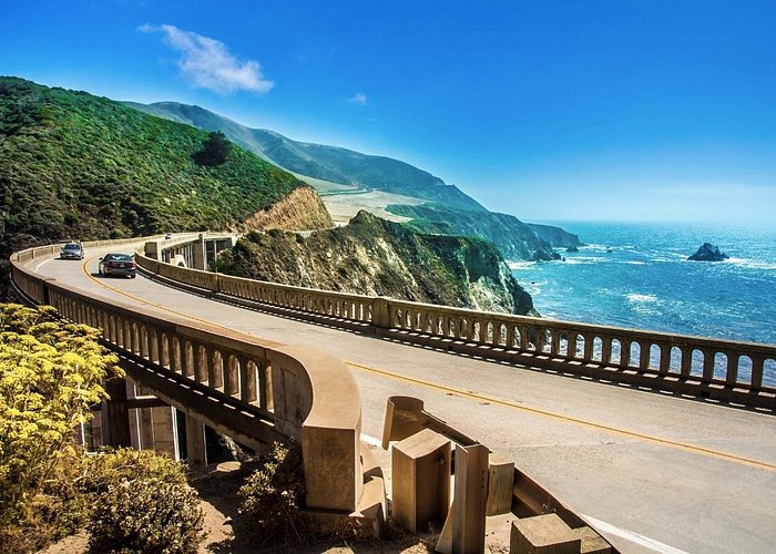
The Big Sur coast is the star of Highway 1. This iconic stretch runs about 90 miles. It connects the charming town of Carmel-by-the-Sea to San Simeon.
For the best experience, drive from north to south. This puts the breathtaking ocean views on your side of the road.
Your camera will get a workout here. Stop at the famous Bixby Creek Bridge for that perfect shot.1 Visit Pfeiffer Beach to see its unique purple sand and Keyhole Arch.
And do not miss McWay Falls. This stunning waterfall tumbles directly onto the beach at Julia Pfeiffer Burns State Park.
My Tip: Your GPS will fail you here. Big Sur’s remote beauty means there is almost no cell service. Download your maps and music before you leave Carmel. Also, fill up your gas tank. Fuel prices along this remote coast are incredibly high.
2. Avenue of the Giants: A Drive Through an Ancient Forest
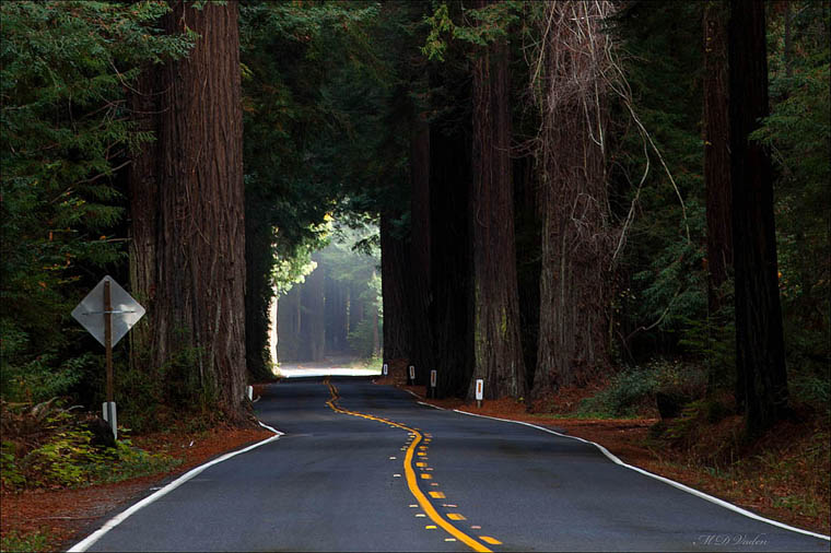
Escape the freeway for a journey back in time. The Avenue of the Giants is a 31-mile scenic detour.
This road, State Route 254, runs parallel to Highway 101. It winds through the magnificent Humboldt Redwoods State Park.
Make sure to stop at Founders Grove. A short half-mile trail leads you to the fallen Dyerville Giant. This massive tree was an estimated 2,000 years old.
Hike the Rockefeller Loop Trail. It takes you through the world’s largest old-growth coastal redwood forest. Do visit the Shrine Drive-Thru Tree.
My Tip: This drive is not a shortcut; it is the entire point. The Avenue of the Giants was the original Highway 101. Choosing this path is a deliberate decision. You trade freeway speeds for a timeless journey among giants that were ancient when California was just a dream.
Sierra Nevada Adventures: Peaks, Passes, and Alpine Lakes
The Sierra Nevada range is the granite heart of California. Here, you will find high-altitude passes and crystal-clear lakes. Epic mountain vistas appear around every corner.
The sheer scale of the landscape confirms that California’s one of the best states for road trips.
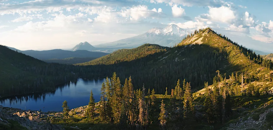
3. Highway 395: The Eastern Sierra’s Majestic Backbone
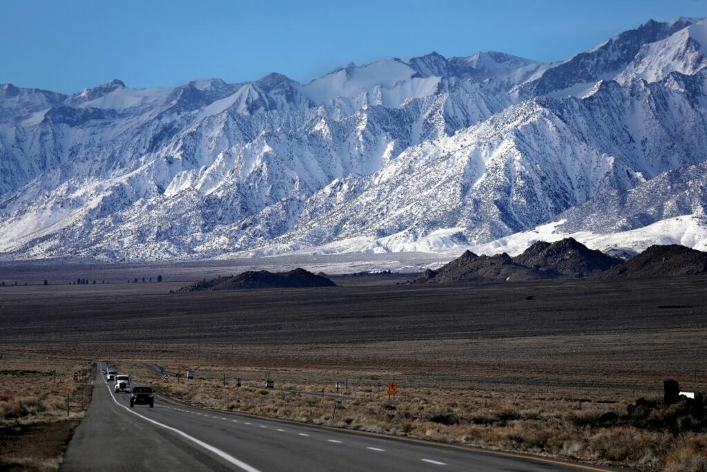
Highway 395 is a lifeline that parallels the Eastern Sierra. This route stretches from the high desert near Lone Pine north toward Lake Tahoe.
The scenery is consistently spectacular. It is a journey through one of America’s most stunning mountain landscapes.
Key photo stops are everywhere. Explore the Alabama Hills near Lone Pine. Its rounded boulders were the backdrop for hundreds of movies. Here you will find Mobius Arch, which perfectly frames Mount Whitney.
Further north, visit the otherworldly Mono Lake. Its strange “tufa towers” create a surreal scene, especially at sunrise.
Finally, take a detour to Bodie State Historic Park. It is the largest unrestored ghost town in the West.
My Tip: Do not just drive this route—taste it. The highway is dotted with legendary food stops. Grab amazing barbecue at Copper Top in Big Pine. Stock up on delicious sheepherder’s bread at Erick Schat’s Bakkery in Bishop. And do not miss the surprisingly gourmet Whoa Nellie Deli at the Tioga Pass Mobil station.
Also Read: 10 U.S. Road Trips Every Retiree Should Take Before It’s Too Late
4. Tioga Pass Road: A High-Altitude Yosemite Experience
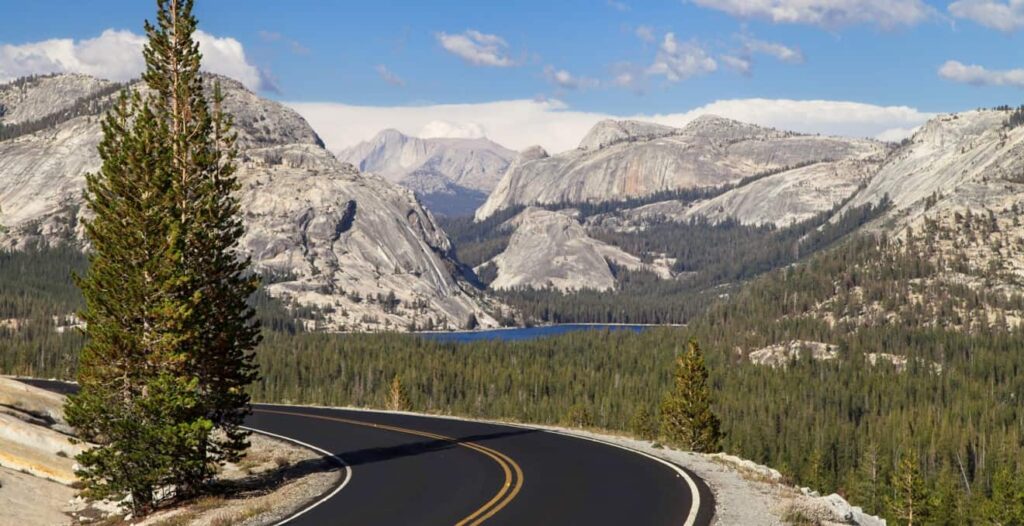
Open only for a few precious months a year, Tioga Pass Road is special.
This 45-mile seasonal route (Highway 120) cuts through Yosemite’s high country. It connects Crane Flat to Highway 395 at Lee Vining. At 9,945 feet, it is California’s highest highway pass.
The views are simply breathtaking. Your first major stop should be Olmsted Point. It offers a stunning view of Half Dome’s granite backside.
Next, you will arrive at Tenaya Lake. This beautiful alpine lake is surrounded by massive granite domes.
Further east lies Tuolumne Meadows. This vast, green meadow offers a beautiful contrast to the rocky peaks.
My Tip: This drive is defined by its fleeting nature. The road is typically open only from late May or early June until the first major snow in October or November. Always check the Caltrans website for opening and closing dates before you plan your trip.
5. June Lake Loop: The Sierra’s Hidden Gem
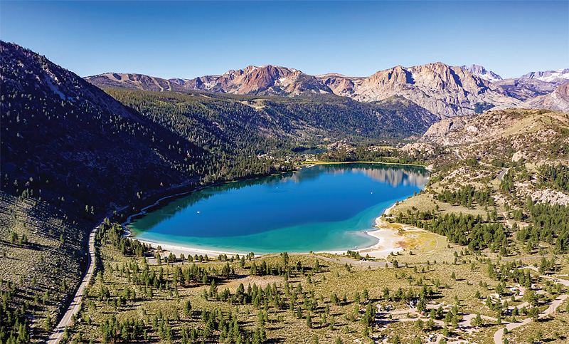
Tucked away off Highway 395 is a perfect detour. The June Lake Loop is a scenic 16-mile drive on Highway 158. It follows a horseshoe-shaped canyon carved by a glacier. The road circles four stunning alpine lakes.
Each of the four lakes—June, Gull, Silver, and Grant—has its own charm. June Lake offers a sandy beach perfect for a summer swim. Silver Lake boasts a dramatic mountain backdrop that is perfect for photos.15
This drive is especially famous for its fall colors. It is one of California’s best spots to see autumn foliage. The aspen trees lining the road turn brilliant shades of gold and orange.
My Tip: For the best photo of the road itself, find a safe pullout near the southern entrance. The view of Highway 158 winding down into the valley is iconic. It features the snow-capped Carson Peak in the distance, creating a classic Eastern Sierra image.
Desert & Mountain Escapes: From Canyons to Summits
California’s deserts and southern mountains are surprisingly diverse. You can drive from colorful badlands below sea level to cool, pine-forested peaks. This dramatic contrast is another reason why California’s one of the best states for road trips.
6. Artist’s Drive: Death Valley’s Painted Hills
This 9-mile, one-way paved loop is located in Death Valley National Park. It is a narrow, winding road with sharp dips, so vehicles over 25 feet are not allowed.
The main attraction is Artist’s Palette. This viewpoint overlooks hillsides painted in vibrant colors.
Volcanic mineral deposits have stained the rock in shades of green, pink, and purple. The colors come from the oxidation of different metals in the clay. It is a true natural masterpiece.
My Tip: Timing is everything on this drive. The colors of Artist’s Palette are most vivid in the late afternoon. The low angle of the sun brings out the mineral hues. It eliminates the harsh shadows of midday, when the heat is also most intense.
7. Geology Tour Road: Joshua Tree’s Rugged Heart
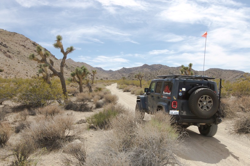
This 18-mile dirt road explores a remote part of Joshua Tree National Park. The first few miles are usually fine for a regular car. However, a 4-wheel-drive vehicle is highly recommended to complete the full loop.
The road opens into the vast Pleasant Valley. It offers panoramic views of the park’s spectacular rock formations. You will feel like you have entered a prehistoric landscape.
Stop at Squaw Tank to see grinding holes left by Native Americans, a tangible link to the area’s human history.
My Tip: This drive is your portal to the park’s wild side. There are no services out here. Pack extra water, have a full tank of gas, and let someone know your plans. Your reward is incredible solitude and a truly ancient landscape.
8. Rim of the World Scenic Byway: A SoCal Mountain High
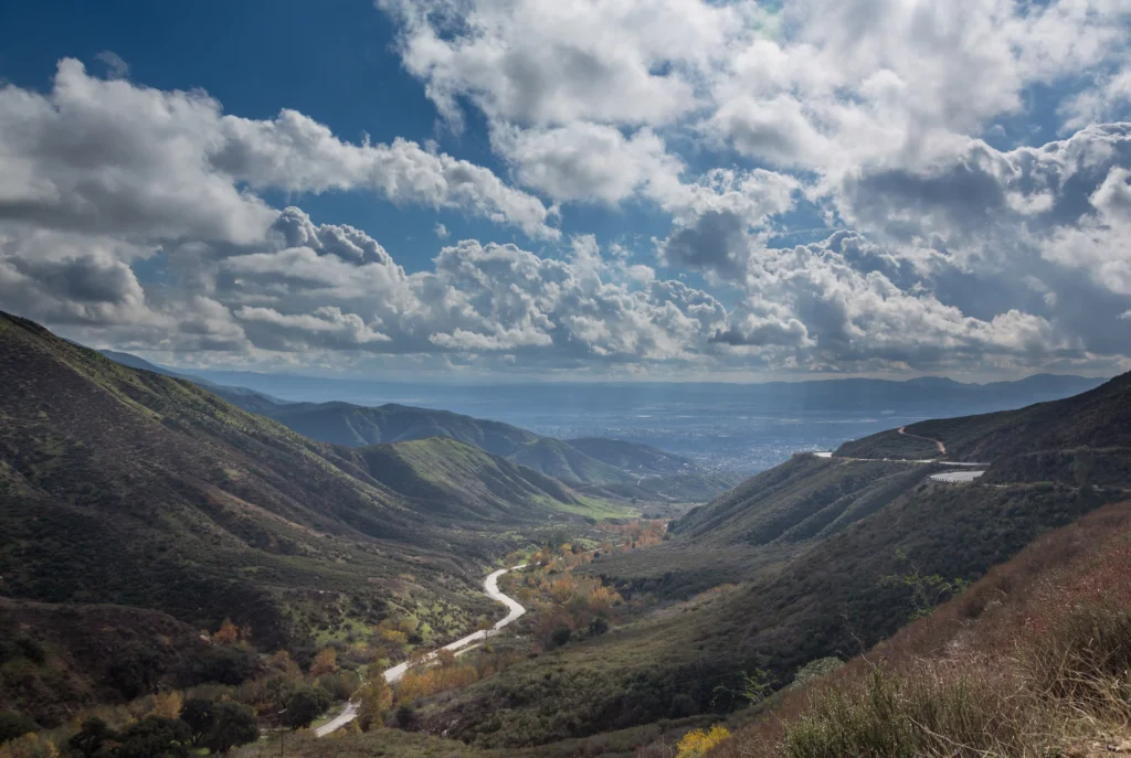
This 110-mile byway lives up to its name. It traces the dramatic cliffs of the San Bernardino Mountains.
The route uses Highways 138, 18, and 38 to connect Cajon Pass to the Big Bear area. You will feel like you are driving on top of the world.
Take a detour to visit Lake Arrowhead. This charming village and deep-blue lake feel like a slice of the Alps in Southern California.
The drive culminates at Big Bear Lake. This popular mountain resort offers year-round recreation and beautiful alpine scenery. On a clear day, views from spots like Keller Peak Fire Lookout are incredible.
My Tip: This drive is spectacular all year, but it transforms in winter. After a fresh snowfall, the views are breathtaking. Seeing the snow-dusted pines against the vast city basin below is unforgettable. Just be sure to carry chains, as they are often mandatory.
9. Palms to Pines Scenic Byway: From Desert Heat to Cool Pines
The Palms to Pines Scenic Byway is a 67-mile drive. It showcases one of California’s most impressive elevation gains. The route climbs from the desert floor of Palm Desert into the cool San Jacinto Mountains.
A must-stop is the Coachella Valley Vista Point on Highway 74. It offers sweeping views of the entire Palm Springs area.
Continue climbing to the charming town of Idyllwild. This artsy mountain community is nestled among tall pines and is perfect for lunch.
Lake Hemet provides a serene mountain contrast to the desert you just left behind.
My Tip: Pay close attention to the plants. The speed at which the flora changes is the real story of this drive. You will go from desert cacti to pinyon pines and then to towering conifers. It is a botanical masterclass viewed from your car window.
Northern & Wine Country Routes: Rivers, Gold, and Vines
Our final drives capture the unique character of Northern California. One is steeped in Gold Rush history along a wild river. The other explores the cultivated beauty of world-famous vineyards.
10. Trinity Scenic Byway: A Trip Through Gold Rush Country
This 140-mile route on Highway 299 runs from Redding to the coast. It follows the path of the wild and scenic Trinity River. The drive offers a mix of natural beauty and fascinating history.
Stop in Weaverville, a wonderfully preserved Gold Rush town. Its Joss House, a Taoist temple built in 1874, is a historical gem.
The road runs alongside the sparkling Trinity River for much of the way. There are countless pullouts to photograph its clear waters and dramatic canyon walls.
Near Redding, explore the brick ruins of Old Shasta State Historic Park.
My Tip: Look for the old bridges. In many places, you can spot the original, abandoned roadway from the early 20th century. These relics are a tangible link to the region’s rugged past. They also make for compelling, historical photos.
11. Silverado Trail: Napa Valley’s Most Scenic Wine Route
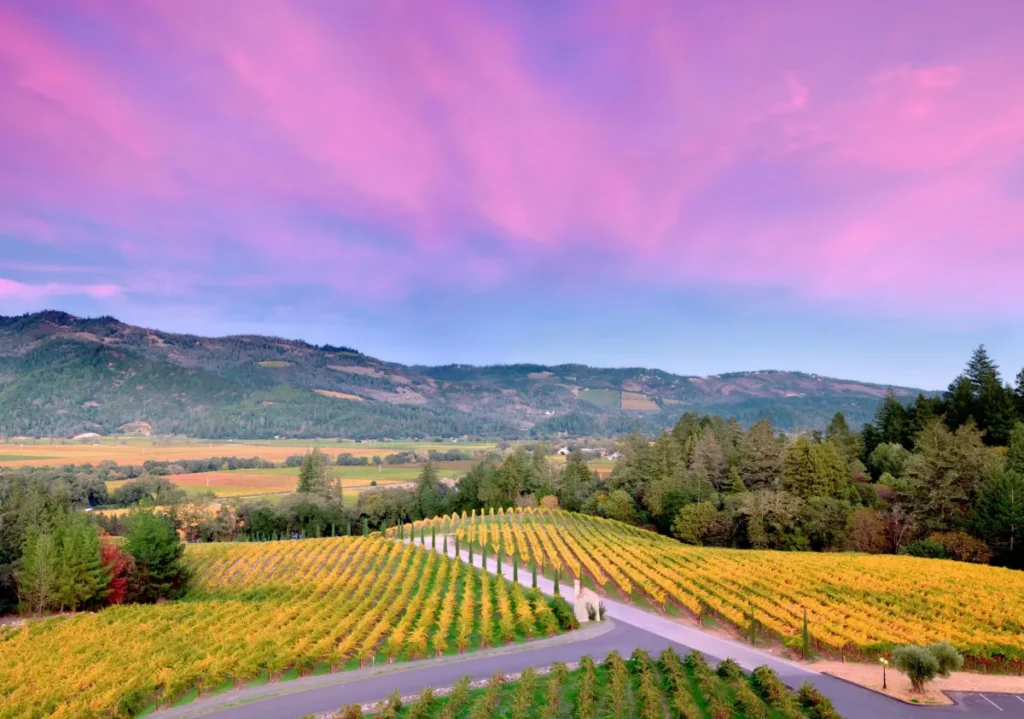
The Silverado Trail is a 29-mile country road. It runs along the eastern edge of Napa Valley from Napa to Calistoga. It is the more scenic alternative to the busy Highway 29.
The drive is lined with rolling vineyards and oak trees. The dramatic cliffs of the Stags Leap district provide a stunning backdrop. The trail is home to dozens of world-class wineries.
Many, like Stag’s Leap Wine Cellars and Mumm Napa, have beautiful architecture and grounds perfect for photos.
My Tip: Rent a bike. The Silverado Trail has a dedicated bike lane and is relatively flat. Hopping from winery to winery on two wheels is the best way to immerse yourself in the sights, sounds, and smells of wine country.
California’s 11 Most Scenic Drives: A Quick Guide
This table gives you a quick look at our top drives. Use it to find the perfect adventure for your next trip.
Drive Name
Region
Approx. Length
Best For
Pacific Coast Highway
Central Coast
90 miles (Big Sur)
Iconic coastal views, dramatic cliffs
Avenue of the Giants
Northern Coast
31 miles
Towering old-growth redwood forests
Highway 395
Eastern Sierra
300+ miles
Majestic mountain peaks, alpine lakes
Tioga Pass Road
Sierra Nevada
45 miles
Yosemite’s high-country grandeur
June Lake Loop
Eastern Sierra
16 miles
Quaint mountain towns and fall colors
Artist’s Drive
Death Valley
9 miles
Surreal, colorful desert landscapes
Geology Tour Road
Joshua Tree
18 miles
Rugged desert backcountry, rock formations
Rim of the World Byway
Southern Mountains
110 miles
Panoramic mountain and valley vistas
Palms to Pines Byway
Southern Desert/Mtn
67 miles
Dramatic desert-to-forest elevation change
Trinity Scenic Byway
Northern California
140 miles
Wild rivers, Gold Rush history
Silverado Trail
Wine Country
29 miles
Rolling vineyards and world-class wineries
Adventure California
California’s beauty is an incredible spectrum of experiences. You can see coast, mountains, desert, and forest, often on a single tank of gas. This amazing diversity is what sets the Golden State apart.
We have given you the map. The adventure is now yours to write. So, which of California’s most scenic drives will you take first?